
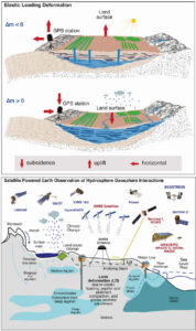
 Redistribution of water across groundwater, surface water, soil moisture, snow, ice, and permafrost exerts stress on the solid Earth and produces measurable deformation. Observed by GNSS, InSAR, and satellite gravimetry, these load-induced displacements provide an integrative, physically grounded constraint on terrestrial water storage (TWS) variability that complements traditional hydrological observations. Ground-based monitoring networks are often sparse, unevenly distributed, and costly to maintain. Satellite-based approaches are therefore essential for advancing consistent monitoring and understanding of water resources in what the United Nations has termed an era of “global water bankruptcy.” Over the past two decades, satellite geodesy has transformed detection of hydrological mass change, yet translating geodetic signals into robust water storage estimates remains challenging due to uncertainties in Earth structure and interference from other deformation processes. At the same time, new satellite missions increasingly resolve individual water-cycle components, creating opportunities for integration but also raising unresolved questions across scales.
This ISSI International Team will develop a coherent framework for integrating satellite geodetic and hydrological satellite observations to improve the estimation of TWS variability from local to global scales. Through coordinated synthesis of elastic hydrological loading theory, Earth model parameterization, and multi-mission observations, the team will assess key uncertainties, evaluate integration strategies, and provide guidance for applying loading models and inversion approaches across scales. The main outcome is a synthesis paper and community recommendations for next-generation estimation of water storage.